Southern Utah is home to some of the most bizarre landscapes on the planet. Those who have been to Arches, Bryce Canyon and The San Rafael Swell know precisely what I mean. Even when compared to these more famous destinations, though, Goblin Valley stands out as strange and unique. I doubt there's anyplace quite like it anywhere in the world. Last May I tagged along with a church group for three days of hiking and camping in the Goblin Valley area.
We camped here, about three miles outside of the park. There are spots inside the park with fire rings, running water, even toilets if your into that sort of thing. We elected to rough it, though, and I'm glad we did...the stars were unreal out there away from any light pollution. And the coyotes were loud around us all night.
Goblin Valley is so named for the thousands of sandstone "hoodoos" that haunt the valley floor. They were formed by millions of years of erosion by wind and water. Now only the hardest, most resistent parts of the rock remain. Giving us these wild shapes.
A few of our youth leaders wandering through the hoodoos.
Several Sci-Fi movies have been filmed in Goblin, and for good reason...it feels completely Martian (though I must admit I've never actually been to Mars).
Perhaps you recognize this place from galaxy quest?
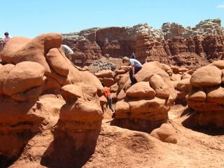
It's totally juvenile, I know, but it's awfully hard to beat a game of steal the flag or "Alien" in Goblin Valley. Especially at night.
Goblin Valley State park is one of the coolest places in Southern Utah, and at risk of sounding completely cliche, that's saying something. Unlike most other parks in the region, Goblin is relatively small (scarcely one mile by two miles) and can be fairly easily explored in a single morning or afternoon. You don't have to be in great shape, and you don't need an entire day to enjoy it. Moreover, there are other things to see in the area. The San Raphael Swell and Little Wild Horse Canyon are only minutes down the road. There's also Horshoe Canyon, home to arguably the best ancient rock art in the Southwest, barely a half hour away.
Any tour of Southern Utah's great parks would be incomplete without a diversion to Goblin Valley. Even a very short visit would be worth the detour.
More to come...maybe from horseshoe Canyon?
Wednesday, April 19, 2006
Saturday, April 01, 2006
Last weekend a friend from work, Scott Seal, and I paid a visit to Utah's West Desert. The West desert is part of the Great Basin, and one of the last truly open spaces in the lower 48.
It's not exactly a tourist destination, though. There's a whole lot of nothin' out there! People only really go out there for three things; minerals, fossils and solitude (one can spend weeks on end out there and see nary a soul). We were after a little solitude, and a few trilobite fossils if we could find them.
We took highway 6 ("The Lonliest Highway") about 30 clicks past Delta, into no man's land. From the 6 we turned right onto a dirt road marked by a U-dig Fossil sign. We followed this road for something like 20 miles, until we reached antelope springs, and the U-dig fossil quarry. Instead of paying to dig on their property, though, we found our own little outcropping of the Wheeler Shale a few miles away and began our search there. Within a couple hours we had found some pretty nice trilobites and decided we had done enough rockhounding. So we hopped back in the truck and headed for Marjum Canyon.
Here's a view from Antelope Springs as we left. In the distance you can see the wind pushing huge clouds of salt across the sevier dry lake bed.
Marjum Canyon is a deep gorge seperating the lower and middle house ranges, and one of Utah's lesser known scenic wonders. From the bottom, huge limestone cliffs tower 400 to 500 feet above you. If it weren't in the middle of ruddy nowhere, I suspect Marjum Canyon would be much more popular. I'm content, however, keeping it a secret (nobody really reads these blogs, right?).
Marjum canyon in the early evening.
One of many cool limestone features in the canyon.
Another limestone cliff at the western end of the canyon.
A view of the Tule Valley, and the Deep Creek range some 70 miles in the distance. I wonder how close the nearest living person was from us at this point?
From Marjum Canyon we found our way to a little spot called Painter Springs. This place is one of the coolest in all of utah, and an incredibly delicate ecosystem. For this reason, I won't disclose the exact location of the springs...if you want to visit, I'll happily take you there.
Painter Springs owes it's existence to a huge body of granite that made it's way through the earth's crust during the time of the dinosaurs. This Granitic rock makes for great aquifer material. Storing water in it's fractures and fissures, it trickles out year round. Aside form being wetter and greener than the surrounding landscape, Painter Springs is spectacular because the pink/orange granite has weatered into so many bizzare and dramatic shapes.
Like this.
And this.
Looking into the basin and range from Painter Springs.
It was getting late so Scott and I had to hit the road. We passed to the west of the lower House Range, and Notch peak on our way back to highway 6. Here is Notch Peak as the sun was setting. More to come...
Subscribe to:
Posts (Atom)